Verjuice Press / Beam Press – Farndale

Geotag Icon Show on map

This verjuice press lies partially covered by a tree in Farndale. Verjuice is the acidic juice of crab apples, traditionally used in cooking and medicine. A large stone would have been placed on top and a beam used to make it squeeze the fruit, with the juice running out of the carved channels.
Verjuice Press, Farndale
This photograph of an olive oil press gives a good idea of how it would have worked.

Mystery ‘Pease’ stone, Loftus – SOLVED – Bible Christian Chapel

Geotag Icon Show on map

Initially I drew a complete blank on this one, but from the many comments Loftus historian and local Councillor, Eric Jackson, thinks he has answer. For a period between the 1890′s and WW2 the site housed the Loftus Bible Christian Chapel, and he feels that the stone is a survivor from that church

Pease Stone, Loftus
The stone looks to have been laid as a dedication stone on what is now a garage.
Pease Stone, Loftus
Best I could come up initially was “A Pease” followed by an obscured date.

The new information helped me locate a direct link to “A Pease” and the Bible Christian Chapel in 1882.

PEASE

Sustrans Heritage Walks 2014

I’ve linked to a few of the sites covered, heres the full details

Skelton High Street West (led by Peter Appleton)
When: Wednesday 16th July
Start: 10:30am, outside Skelton Library
Length: 2.5 hours
Skelton High Street divides naturally into an eastern half and a western half at Coniston Road. This walk explores the heritage to be found in the western half on a gentle stroll to the old church tucked away on the edge of the Castle grounds

Panniermans Causeway (led by Marshall Best)
When: Wednesday 23rd July
Start: 10:30am, Loftus Square, outside the Co-op
Length: 4 hours
Panniermen transported coal and wool, along the long trod (flagged paths) from Loftus. This walk is a charming look at these effective transport links.

Obscure Guisborough Railways (led by George Featherston)
When: Wednesday 13th August
Start: 10:30am, Guisborough Forest & Walkway Centre
Length: 5 hours
The Guisborough valley once had two main railway lines and several branches. We’ll explore them and their often swashbuckling history while we enjoy the fine countryside and wildlife.

Scaling Dam & Radar Station (led by Marshall Best)
When: Wednesday 20th August
Start: 10:30am, Scaling Dam Sailing club car park, TS13 4TP
Length: 4 hours
Examining the former site of the RAF Danby Beacon, including the plaque commemorating the date the first enemy aircraft was shot down in Britain in WW2, after being detected by radar at Danby Beacon.

Ironstone Mining Heritage 2 (led by John Roberts)
When: Wednesday 17th September
Start: 10:30am, Bank Top Car Park, Staithes
Length: 3.5 hours
Looking at the Grinkle and Boulby mines, this walk will also reference the active potash mine in Boulby. This walk is entirely within the North York Moors National Park.

Two Mines Circular (led by Peter Appleton)
When: Wednesday 24th September
Start: 10:30am, outside Skelton Library
Length: 4 hours
This walk takes us up the Cleveland Way towards Skelton Green before heading off down Trout Hall Lane past Skelton’s coal mine. We then continue to North Skelton, site of the last ironstone mine to operate in Cleveland (which closed 50 years ago this year!). After a picnic lunch we continue to the site of Longacres ironstone mine before heading back to the library.

Hinderwell ROC Post – Back to where it all began.

Geotag Icon Show on map

In May 2002 I was fortunate enough to visit this post when it was dry and completely intact, there were maps on the walls, magazines in the drawers and even a message left by the last watch. Before I could return and take photographs the entrance was filled with soil and access was lost. Luckily Nick Catford managed to get photos around that time.
I always regretted the missed opportunity and not having recorded it when I had the chance, so those events were in my mind when I came to start up this website.
However after a lost decade the site is once again open.
Hinderwell ROC Bunker
Sadly due to the lid being thrown down the hole, water is getting in its in poor condition.
Hinderwell ROC Bunker
This metal plate was where the ‘Bomb Power Indicator’ was mounted.
Hinderwell ROC Bunker
The air vent has taken a lot of abuse, being nearly smashed to pieces.
Hinderwell ROC Bunker
Inside the entrance is now half-filled with soil
Hinderwell ROC Bunker
The contents of the post is generally trashed and all the papers and maps gone.
Hinderwell ROC Bunker
A couple of nice features still remain, such as a hand-written note about sounding the siren, protected from damp by glass.
Hinderwell ROC Bunker
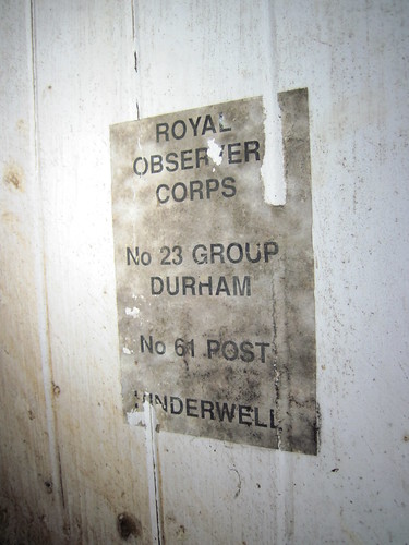
The back of the door also has a notice of the post name and number still attached.