Pirate Cat and HMS Redcar

Geotag Icon Show on map

I can find no details about this little character perched up in a birds nest, any info would be gratefully received.
Pirate Cat in Crows Nest, Redcar

The mast is a half-scale replica of HMS Redcar, a ‘Racecourse’ class minesweeper that was sunk on 24th June 1917 near Dover.

HMS Redcar HMS Redcar

Update 2/3/2011 : The mast and most of the old tourist information centre were demolished today. It looks like the plaques were taken away beforehand, hopefully the little cat was rescued too !

St Germains Church, Captain Cooks Fathers Grave

Geotag Icon Show on map

Only the tower of St Germains remains, built in 1160. The church was rebuilt in 1821 but again demolished in 1950 with exception of the Tower.

St Germains Church, Marske St Germains Church, Marske

Captain Cooks father is buried here, he died in 1779 six weeks after Cook himself, although never knew his sons death.

Captain Cooks Fathers Grave - St Germains Church 

The current headstone is erected in the memory of James Robinson who was lost as sea in 1904. The grave is also reputed to have been visited by Charles Dickens.

Pillbox, Low Grange Farm, South Bank

Geotag Icon Show on map

This Type 23 pillbox is visible in a field beside the Trunk Road between Redcar and Middlesbrough.

Pillbox, Trunk Road, South Bank Pillbox, Trunk Road, South Bank Pillbox, Trunk Road, South Bank

The pillbox is under threat of destruction due to the re-development of the area.

The council development plan says :- “The World War II Pill box should be retained on the site, if possible, or buried in situ, otherwise it should be recorded prior to demolition.” As that particular area is pencilled in for shops/pubs/takeaways, I strongly suspect the latter will be the outcome. The land itself that the farm stood on was owned by the Lady Hewley Trust, giving it a link back to the Eston ironstone mines.

As that particular area is pencilled in for shops/pubs/takeaways, I strongly suspect the latter will be the outcome. The land itself that the farm stood on was owned by the , giving it a link back to the Eston ironstone mines. 

UPDATE 10/08/2011 : Drove past this morning and sadly it looks like the pillbox has recently been removed as I strongly suspected it might.

Duck Bridge – Danby

Geotag Icon Show on map

Duck Bridge was originally known as Danby Castle Bridge (the remains of which are 500m away)

Duck Bridge Duck Bridge Duck Bridge

It is probably medieval in original and was rebuilt in 1717 by George Duck of Danby. It was possible to drive across until a ford was built a few years ago.

Duck Bridge  Duck Bridge

The Neville Coat of Arms can be seen on the parapet, and a set of stepping stones run beside the bridge.

Tunnel under road at Boulby

Geotag Icon Show on map

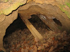
Although there ironstone workings in the immediate area and this looks like a drift I dont think it is.

Boulby Tunnel under road

I think this is more likely the location where the culvert from the Boulby Alum Works passed underneath the road on its way to the Alum House for processing.

 Boulby Alum House

The house is probably not original, although a wall in the garden at the edge of the cliff looks much older. The vertical shaft from the Boulby Alum Tunnel on the shore would emerge in the garden of this house were it still open.


Aislaby Stone and Quarry

Geotag Icon Show on map

Aislaby Quarry was a source of blockstones in the 17th and 18th Century for harbours such as Whitby, Margate and Ramsgate, and the Strand Bridge in London.

The blockstone was returned from the Whitby pier in 1964

Aislaby Stone Aislaby Stone

The quarry reopened in 2002, I have read that in the 1970s the remains of a jet mines were also accessible, but the whole area seems to have been freshly opened up, so I doubt the current owners would take kindly to visitors searching for any remains.

Aislaby Quarry Aislaby Quarry

Eston Nab – Iron Age Hill-fort and Napoleonic Beacon

Geotag Icon Show on map

The remain of earthworks surrounding the Iron Age Fort are still very prominent on the ground.

Eston_Nab_-_Iron_Age_hillfort

Tees Archaeology have produced an excellent leaflet on the subject here.
Eston Nab Ironage Hill Fort Eston Nab Ironage Hill Fort

The Napoleonic Beacon was built in 1808 as part of a chain to warn of attack.

The actual watchtower appears to have been built and little later around 1819/1820 (thanks to Joan for the additional information), that later became a private residence and was inhabited up until the 1950s.

phplJGkyn

It was demolised in 1956 and ICI erected the current monument.
Eston Nab Eston Nab Eston Nab

The view from the top is still spectacular

Eston Nab

Ayton Banks Ironstone Mine

Geotag Icon Show on map

Ayton Banks was mined by three different companies between 1909 and 1929, it was a small royalty entirely enclosed within Ayton Monument mine.
The most obvious remains are the numerous shale heaps, some with ironwork on top probably from aerial ropeways.

Ayton Banks Ironstone Mine

A number of building remains and foundation can be spotted in the dense undergrowth

Ayton Banks Ironstone Mine Ayton Banks Ironstone Mine  Ayton Banks Ironstone Mine

A very small length of drift is visible at the bottom of a large collapse, but its tricky to reach and also flooded.

Ayton Banks Ironstone Mine

About 100m to the south of the drift, iron stained water can be seen emerging from what was presumably a drainage level, this appears to be lined with corrugated iron sheets which have collapsed a few feet in, water can again be seen at the bottom of that collapse.

Ayton Banks Ironstone Mine  Ayton Banks Ironstone Mine