Chop Gate Mystery Stone Marker

Geotag Icon Show on map

Located on a bridge at the edge of Chop Gate, i’ve been puzzling over this one for a week and cannot locate any references to it online.
Chop Gate stone
My best guess is the third line is ‘LANDRO’ and the fourth line “ADEND’ if you ignore the lack of spaces that could be “…land Road End”

I suspect its a parish boundary and could be a roadmens stone like the one at Rosedale / Farndale

Kirkdale Cave

Geotag Icon Show on map

Kirkdale Cave was discovered by quarrymen in 1821 and documented by William Buckland in 1822.
Kirkdale Cave
It had been used a hyena den and contained bones from animals such as elephants, hippopotamuses, rhinoceroses and bison from around 125,000 years ago.
Kirkdale Cave
This was controvesial at the time as the church was of the position they were deposited by the biblical flood.
kirk_entr

Lingdale Cycling Memorial

Geotag Icon Show on map

This recently erected sculpture and information board commissioned by Lingdale Lift Off Community Group records the cycling heritage of Lingdale.
Lingdale Cycling Memorial

Lingdale Cycling Memorial
Lingdale Cycling Club had its own cycling track in the late 1800s as shown on this map, although the original was covered by the shales waste from the ironstone mine.
track1

It was then relocated to the south of the mine site as shown on early 1900s maps.
track2

Whorlton Suspension Bridge

Geotag Icon Show on map

The first bridge at Whorlton was started on 9th June 1829, on 13th October 1829 the incomplete bridge was swept away in a huge flood.

Whorlton Suspension Bridge

The foundation of the north pier of the replacement chain bridge was laid on 19th August 1830 with the main chains being slung on 1st April 1831, the complete bridge opened on 7th July 1831.

Whorlton Suspension Bridge

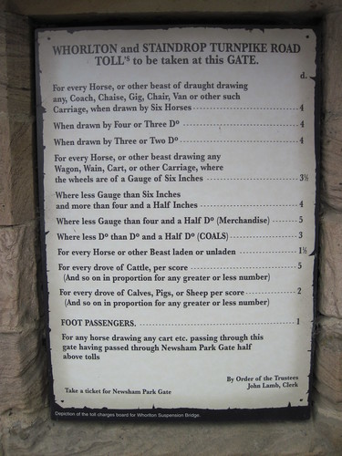
The architect was Mr Green of Newcastle and the builder Welsh of Gateshead. The toll booth at the north end carries a reproduction of the fees to cross.

Whorlton Suspension Bridge