Slag Works, South Gare

Geotag Icon Show on map

These extensive concrete remains lie just North of the current SSI Blast Furnace.
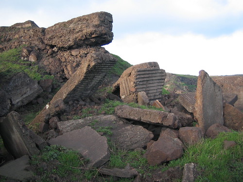
South Gare, Slag Plant Remains 1
South Gare, Slag Plant Remains 2
South Gare, Slag Plant Remains 3
South Gare, Slag Plant Remains 4
South Gare, Slag Plant Remains 5

A post war map shows this structure between the Warrenby Slag Works and the Slag and Tarmacadam Works.

To me the layout of rails and concrete blocks suggest a row of storage hoppers which rail waggon could be driven underneath for loading, although i’m yet to find an old picture of what was actually here.

US Presidents Daughter in Kirkleatham

Geotag Icon Show on map

Esther Cleveland (September 9, 1893 – June 25, 1980) was the daughter of American president Grover Cleveland, she is the only child of a President to have been born in the White House.
William and Esther Bosanquet, Kirkleatham
Esther married Captain William Bosanquet in 1918,  who became the manager of Skinningrove Iron Works after fighting in the First World War, they lived in Kirkleatham Old Hall which is now a museum.

This 1934 newspaper article from America newspaper pictures her outside the Hall, Esther returned to America in 1966 after the death of her husband and is buried in New Hampshire

Their daughter was the British philosopher Philippa Foot.

Ayresome Gardens Vaughan and Gjers Grave Markers

Geotag Icon Show on map

As I was driving past this morning, I noticed Steve Waller marking out some grave locations in the park, presumably for Heritage Week.
Vaughan and Gjers Graves, Middlesbrough
John Gjers was an ironmaster owning the Gjers Mills Ayresome Ironworks, Florence Gjers (his second wife) was the last burial in the park on 8th August 1950

John and Florence Gjers Grave, Middlesbrough
Immediately next to them is John Vaughan Jr (19 year-old son of the founder of Bolckow and Vaughan)
John Vaughan Jr Grave, Middlesbrough
You’ll probably have to be quick if you want to catch these and all the others that were marked out.

Ormesby Beck meets the Tees

Geotag Icon Show on map

Things look pretty un-inspiring when you start behind the ‘Navigation’ near to the Riverside Stadium with the beck just being a concrete sided trough with clogged rubbish traps.
Ormesby Beck
As you move east things take a turn of the better.
Ormesby Beck
A little futher on are some gates, perhaps some sort of flood defence as this area will be tidal ?
Ormesby Beck
After these it becomes rather pleasant with some ducks being seen.
Ormesby Beck
The beck then takes a sharp turn to the north and join up with River Tees.
Ormesby Beck joins the Tees

This would have been a very industrial location in the past surrounded by iron works, although the area to the south was a marsh. It doesn’t exist on the 1858 map as the beck flows under the railway near to the Navigation Inn, but this redirection to the opposite side of railway exists on the 1894 map perhaps due to the construction of the Ormesby Ironworks.

Forgotten park at Cargo Fleet Wharf

Geotag Icon Show on map

This area looks to have been developed as a public park in the late 1980s but is no longer maintained and tricky to reach for the public. It was actually opened by Prince Charles
Cargo Fleet Wharf
At the top of the hill is a viewpoint which has been vandalised in the past, but looks forgotten about now.
Viewpoint at Cargo Fleet Wharf
No traces of any older structures are visible, although the view up the river towards Middlesbrough is still good.
View from Cargo Fleet Wharf
Down by the riverside is interesting as this is one of the only points downstream of Middlesbrough you can access the banks of the Tees without being on private property.
Cargo Fleet Wharf
A large concrete pillar stands in the water which may correspond to a Slag Conveyer shown in the 1929 OS map, although i’m by no means certain of that.
Cargo Fleet Wharf


Rows of rotted wooden posts are also visible at the waters edge which presumably are the mooring posts for Cargo Fleet Wharf, although i’m yet to locate a photo of this area in use.
Cargo Fleet Wharf

Bridge between Cargo Fleet Ironworks and Cargo Fleet Wharf

Geotag Icon Show on map

This bridge crossing the main railway now stands isolated behind Dockside Road and the back of the South Tees Motor Sports Park which covers the location of the Cargo Fleet Ironworks
Bridge to Cargo Fleet Wharf
Its inaccessible from either end, presumably to stop vandals throwing things onto passing trains as crossing wouldn’t actually get you anywhere.
Bridge to Cargo Fleet Wharf
Dave Walsh then quickly posed an interesting question about whether this was actually the bridge that carried the Cleveland Railway to the Normanby Jetty, to which I didn’t know the answer. Looking at the 1894 map there are actually two adjacent bridges, the northern one going to the Cargo Fleet Wharf and the southern one going to the Normanby Jetty used by Bell Brothers to transport ironstone to their works at Port Clarence.

The 1915 map appear the show the southerly bridge gone, leaving only the remaining one to the Cargo Fleet Wharf, but i’m by no means certain of all its functions over the years so any additional information would be welcome.

Update : Simon Chapman has kindly shared a 1972 photo of the bridge with me. In front of the bridge on the right can be seen the remaining parapet of the Cleveland Railway bridge to Normanby Jetty which was subsequently demolished. On the left of the photo is Normanby signalbox which controlled the junction for mineral traffic into Cargo Fleet Works.

Greatham Salt Works (Cerebos) , Greatham

Geotag Icon Show on map

The site known as Greatham Saltworks was founded in the late 1800s before becoming Cerebos around the turn of the century. In 1968 Cerebos became part of Ranks Hovis McDougall and products such as Bisto Gravy and Atora Suet were manufactured.
Cerebos Greatham
From 1997 to closure in 2002 some Sharwoods products were made here, on the day I visited it was in the final stages of demolition.
Cerebos Greatham
The internals of site were photographed extensively on urbex sites such as 28 Days Later