A ropeway ran south-west from the main site of the Belmont mine to tip shale in the hillside, since the recent harvesting of the trees in this area the base of part of the ropeway can now be seen on the bare hillside.


 Show on map
 A ropeway ran south-west from the main site of the Belmont mine to tip shale in the hillside, since the recent harvesting of the trees in this area the base of part of the ropeway can now be seen on the bare hillside.
Show on map The second phase of working at Belmont started in 1907-1908 after the original working there ceased around 1886.
Hunters Hill Farm consists of a large range of building which constituted the stables and workshops of the mine, close to the road is a huge concrete wall which one supported one end of the tipping gantry where railway wagons were loaded.
 Â
 
 Â
 
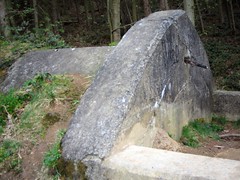
Continuing a short way up the path you first reach the collapsed drift entrance with an electrical sub-station next to it, the remains of ceramic insulators can be seen in its back wall.
 Â
 

A little further up the hill again stands a powder house now filled with earth.
 Â
 
I also noticed that the nearby allotments have a vegetable bed constructed from Pease bricks, although as Pease never ran Belmont they could just be anomalous

Show on map Victoria Ironworks were built between 1856 and 1858, the site is located on a geological fault and this lead to a landslip that destroyed most of the works on 22nd March 1858, only a couple of months after it started production.
 Â
 
The works were rebuilt and stuggled on under various owners for a few year before closing.
Two arches from calcining kilns can still be found on the cliffs
 Â


The site today is difficult to reach and overgrown, the shale cliffs continue to collapse and be eroded. There is a mine shaft filled with water at the cliff edge, it shows the speed of erosion as this was recorded as 90ft from the edge in 1862.
The remain of Victoria Harbour can be identified on the shore by a line of stone.
Show on map This set of kilns for roasting iron ore is located at the top of the banks just outside Rosedale AbbeyÂ
 

 Â
 
This was also the location of the Rosedale Chimney which was demolished in 1972
 An inclined tramway ran from the top of kilns, down toward Hollins Magnetic Mine
 Â
 

I’m afraid I’m keeping the exact location of this one off the site.
Its clearly been forgotten by the local kids due to the lack of any recent litter/beer cans, its only a few hundred meters from a playground and the condition of the place is very poor looking liable to collapse in places, so I don’t want to put it back on their radar.


There are three main areas inside, with several open vertical shafts running to the surface as well as two side entrances.
If you think about ironstone mines still open during the second world war, you may deduce where this is located.
Show on map Cheers to Chris Martin for the information about this additional obelisk, like the two sets in Eston it bears the inscription “Cleveland Ironstone Eston Mines” this one is actually in better condition than all the others.


Not the greatest photos as only had my mobile phone.
Anyone know of any more obelisks ? I believe there used to be another to the North of South Bank, towards the river.
Show on map Waterfall mine was worked between 1892 and 1901, the ironstone here is very close to the surface and under a layer of sand and clay, the dangerous working conditions gave this mine the nickname “Linger and Die”


The whole site is now obscured by a plantation, although hints of a cutting/drift can be seen towards the east corner where the path of a railway can be seen heading across fields on the aerial photo.
Show on map St Oswalds, Tin Tabernacle was erected for the miners of the Kirkleatham Ironstone Mine in 1913

Corrugated iron churches are become rarer, someone sought planning permission to demolish it in 2006 for housing but was fortunately turned down despite this unique building not being listed and in need of repairs.

Update December 2011 – A friend of mine kindly provided a 1977 photo from the Evening Gazette in which demolition of the church is discussed, its such a shame that over 30 years later its still looking just as unloved (but fortunately still intact)

There are also details of how the bell from the church is currently in Titoki on the Bay of Plenty, on the North Island of New Zealand,
Show on map All that remains is a concrete block in the middle of a playing field.
 Â
Â
The plaque read :-
FILLED UPSHAFT, DEPTH 90 METRES, DIAMETER 3.4M, SHAFT FILLED AND CAPPED 1986
A second shaft was close by, all that remains of that is a slight indentation in the field.
Show on map Following on from my previous obelisk post I went out to photograph the two ironstone obelisks on the site of the old Eston miners hospital.
 Â
 
They were removed when the hospital was demolished in 1980 and returned in 2004. They are identical to the two outside the town hall, so i’m unsure where these two went or if there were four at the town hall ?
Â
Â


