Skinningrove 1848 Ironstone Drifts

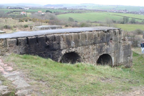
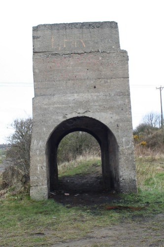
Very close to the Cleveland Ironstone Mining Museum which is well worth a visit to see the later North Drift, are the remains of the original 1848 drift in Skinningrove.

Skinningrove Ironstone Drifts Skinningrove Ironstone Drifts

I have no idea what purpose the cupboard like structure currently inside served, it appears to be from after the tunnel was blocked.
The adjacent small tunnel looks likely to have been for drainage.
Skinningrove Ironstone Drifts

This was the first of the Cleveland ironstone mines and finally closed in 1958-1959.

Keith Electric Fan, Eston Mines

Geotag Icon Show on map

By the side of the tramway that runs through the woods from the Eston mines are the remains of the Keith Fan House, it was used to ventilate an area of workings near the Lowther drift.
Keith Fan Eston Mines Keith Fan Eston Mines

On the side of one of the concrete foundations is the inverted impression of company name.

Keith Fan Eston Mines

The location i’ve given is only approximate, but its easily located walking along the tramway.

Tunnel under Wilton Lane (updated August 08)

I know very little about this, I only picked up on its existence from a Flickr photo. It follows the path which exits the wood so its highly likely its to do with the ironstone mines in Eston.

The track continued in a cutting on the other side of the road, heading off towards Dunsdale, although on closer inspection that is to the north of this area.
A tunnel is marked on this map at Waggonways which also suggest a second tunnel closer to Dunsdale

Tunnel Under Wilton Lane - 4 Tunnel Under Wilton Lane - 9 Tunnel Under Wilton Lane - 8 Tunnel Under Wilton Lane - 7 Tunnel Under Wilton Lane - 3 Tunnel Under Wilton Lane - 1

By way of a disclaimer and warning, its located on a scrambler track (possibly on private land?)

It’s likely unsafe, you’ll get very dirty and need a torch.

*Update 2008* Having visited more mining sites subsequently and spoken to other, I now believe this to be actual ironstone workings rather than a rail tunnel. Its unlined and a bord and pillar arrangement of passages is running parallel to the road not just under it, here are some internal shot taken with a better camera.

Wilton Lane Wilton Lane

Brackenberry Wyke and Old Nab

Geotag Icon Show on map

Making sure to be aware of the tides, the trip between Staithes and Port Mulgrave is a good one, unfortunately I forgot the memory card in the camera, so only phone photos this time.
Old Nab has the remains of ‘bord and pillar’ working now clearly visible on the shore

Brackenberry Wyke Brackenberry Wyke Brackenberry Wyke


Along much of the northern part of Brackenberry Wyke exposes the ‘Pecten’ Ironstone seam, with the fossil shells the seam is named after covering the area.

Brackenberry Wyke Brackenberry Wyke

A large adit into ironstone seams is visible in the cliff at the north end of the Wyke, these workings once extended up to 1km inland although now they are collapsed after a very short distance, the cliff above is also very unstable with stones constantly falling.

Brackenberry Wyke Brackenberry Wyke Brackenberry Wyke

A smaller collapsed adit is visible just a few meters south of the larger one

Brackenberry Wyke Brackenberry Wyke

Much further to the south, just before the large landslip known as Sheepstones, there is another large adit.

Brackenberry Wyke Brackenberry Wyke

However this is a good distance up the cliff and its impossible to tell if it travels from any distance, it would seem extremely unlikely given the fragile nature of all the cliffs in this area.

Blink Bonny

Geotag Icon Show on map

Blink Bonny is apparently Norse for “nice view” and it certainly is (although not on the day I visited due to low cloud)

The drift was associated with the Ailesbury Mines to the north east, a collapsed drift can be seen in the hillside, with the tip in front now being home to a bench and viewpoint.
Blink Bonny Blink Bonny Blink Bonny

The are numerous other tips and collapses in the area at the same level as these working.

Scugdale Calcining Kilns, Swainby

Geotag Icon Show on map

Calcining is the process of roasting iron ore making it more suitable from blast furnaces, these structures are similar to the larger and more obvious kilns in Rosedale.

The location can easily be approached through the woods to the North West along the old railway line which goes directly to the kilns. A large shale tip can be seen through the trees just before arriving.

A groove can be seen in the North West end, presumably it once housed a chute of some kind to load into waggons on the railway below.
Scugdale Calcining Kilns Scugdale Calcining Kilns Scugdale Calcining Kilns

The South East end also has brickwork standing approximately 10m high.
Scugdale Calcining Kilns Scugdale Calcining Kilns Scugdale Calcining Kilns

The back wall of the kilns are the majority of the remains, as the front wall and any dividers have collapsed into a large spread of rubble in front, some of the retaining fittings are still visible in this rubble.
Scugdale Calcining Kilns Scugdale Calcining Kilns Scugdale Calcining Kilns

Layers of firebricks burnt red by extreme heat and it places completely burnt away, can still be seen in position along the back wall.

Scugdale Calcining Kilns Scugdale Calcining Kilns Scugdale Calcining Kilns Scugdale Calcining Kilns

The structure was surveyed in much more detail by John Owen and published in Cleveland Industrial Archaeologist No. 22.

Warren Moor Ironstone Mine

Geotag Icon Show on map

Warren Moor has the only standing chimney of any ironstone mine in the area, dating from the 1860s
Warren Moor Ironstone Mine Warren Moor Ironstone Mine Warren Moor Ironstone Mine

A completely flooded 220ft downcast shaft can be seen from the path.

Warren Moor Ironstone Mine  Warren Moor Ironstone Mine

Between the two shafts are the foundations of a winding engine.

Warren Moor Ironstone Mine Warren Moor Ironstone Mine

A vaulted roof leads from the foundations of a pumping house to the upcast shaft.

Warren Moor Ironstone Mine Warren Moor Ironstone Mine

Warren Moor Ironstone Mine Warren Moor Ironstone Mine

The upcast shaft is estimated to be 150ft deep, not reaching the Main Seam ironstone and not connected to the downcast hence the differing water levels in each.

Warren Moor Ironstone Mine Warren Moor Ironstone Mine

A number of surface drifts can be seen on the hillside to the north east which worked the Top Seam.

Lumpsey Ironstone Mine

Geotag Icon Show on map

The shaft at Lumpsey were started in early 1880 and stuck the ironstone seam 175m down in late 1881.

The mine operated through to November 1954, the majority of the building were demolished around 1964.

Both capped shafts are marked with a pillar and have an inscription (at least a welded one)
Lumpsey Ironstone Mine Shaft
Lumpsey Ironstone Mine Shaft and Fanhouse
Lumpsey Ironstone Mine Shaft

Between the two shafts are the sizeable brick foundations of a steam pumping engine.

Lumpsey Ironstone Mine Pumping Engine
Lumpsey Ironstone Mine Pumping Engine and Shaft
Lumpsey Ironstone Mine Pumping Engine

The circular opening of the Waddle fan house is still visible, although perhaps not for much longer as comparing with pictures from a couple of years ago the top has recently broken.

Lumpsey Ironstone Mine Fanhouse

The largest mass of remains are the concrete foundations of the main winding house.
Lumpsey Ironstone Mine Winding House
Lumpsey Ironstone Mine
Lumpsey Ironstone Mine Winding House

Slightly to the south of the winding house foundations are four concrete blocks which supported steam driven electricity generators.

Lumpsey Ironstone Mine Power Station Bases

A small tower which supported a weighbridge stands between the downcast shaft and the railway line.
Lumpsey Ironstone Mine Weightbridge Support

There are many other fragments of buildings and foundations scattered around in the undergrowth.
Lumpsey Ironstone Mine