Westworth Reservoir

Geotag Icon Show on map

Westworth Reservoir was built by the Guisborough Water Company around 1871, it has in recent years been abandoned.

Westworth Reservoir Westworth Reservoir   

I don’t know the exact date of closure and remodelling, but a 2002 report talks about the cross-section of the dam being left.

Westworth Reservoir Westworth Reservoir Westworth Reservoir

The overflow tower is the most striking reminder, along with a stone spillway which is gradually becoming overgrown.

Westworth Reservoir Westworth Reservoir

A small building and plinth remain for an “interpretation panel” that clearly never materialised.

Plan of Spa Wood workings under the reservoir (triggered by discussion in the comments)

spa-012.jpg


Roxby Mill

Geotag Icon Show on map

My second abandoned mill of the day, in a beautiful but I imagine rarely visited setting. The walls of the buildings are still standing to a fair height and a set of steps is very prominent.

Roxby Mill Roxby Mill Roxby Mill

The mill is located next to an impressive waterfall.

Waterfall near Roxby Mill Waterfall near Roxby Mill

I cannot find any old images of mill, although it was painted by John Syer in the 1800s

Scaling Mill

Geotag Icon Show on map

My copy of “Industrial Archaeology of North East England” from 1974 reports Scaling Mill as being intact with much of the gear still in site, sadly this is no longer the case in 2011. A weir and mill race running towards the mill can still be easily identified. A photo can be found here
 Scaling Mill - Weir Scaling Mill Race
The actual location of mill is little more that a few foundations now, although a small outbuilding is still standing and in the stream there does appear to be a cutting next to wall which could have housed a waterwheel.

Scaling Mill Scaling Mill Outbuilding
Some ruined farm buildings are nearby but away from the stream, they don’t look like they will last much longer either judging by the crack in the end wall.
Buildings near Scaling Mill Buildings near Scaling Mill Scaling Mill - Stopcock
A piece of long abandoned farm machinery is also hidden in the undergrowth.

Old Farm Machinery Old Farm Machinery Old Farm Machinery

Recently lost buildings of Redcar

Much work is ongoing in Redcar and a number of buildings have disappeared in the last year or so, I thought I would capture them from Google Streetview now before they vanish from there too. I doubt any will be considered a loss to the area in years to come.
The Alderman B.O. Davies Health Centre on Coatham Road, demolished

gone6.jpg

Kwik Save on West Dyke Road, demolished

gone5.jpg

Sharky’s on the Sea Front, demolished

gone2.jpg

This one on the right has been derelict for as long as I can remember, but I believe it was once an amusement arcade, demolished

gone.jpgT

The Hydro, not actually demolished, but now converted into flats.

gone4.jpg

Sir William Turners 6th Form / Redcar and Cleveland College, Redcar Lane

Geotag Icon Show on map

Not a building with any aesthetic beauty or history, but a lot of locals including myself passed through.

The Sir William Turners 6th Form was built around 1975 when the Sir William Turner’s School for boys and the Cleveland Grammar School for girls merged. Via further merger it became part of Redcar & Cleveland College in 1994.

These photos were taken during the auctioning off of the buildings fixtures and fittings in late 2008 before it was demolished in early 2009 to make for housing (that was never built due to the global financial meltdown)

Sir Williams Turners (pre demolition) Sir Williams Turners (pre demolition) Sir Williams Turners (pre demolition)

Sir Williams Turners (pre demolition) Sir Williams Turners (pre demolition)

Sir Williams Turners (pre demolition) Sir Williams Turners (pre demolition) 

Sir Williams Turners (pre demolition) Sir Williams Turners (pre demolition)

Sir Williams Turners (pre demolition) Sir Williams Turners (pre demolition) 

Sir Williams Turners (pre demolition) Sir Williams Turners (pre demolition) 

 Sir Williams Turners (pre demolition) Sir Williams Turners (pre demolition)

A couple of interesting items that were in the building but I don’t recall being for sale were the college shield and foundation stone from the original Coatham Road Sir William Turners School. I’m not sure what became of them

Sir Williams Turners (pre demolition)  

Sir Williams Turners (pre demolition) 


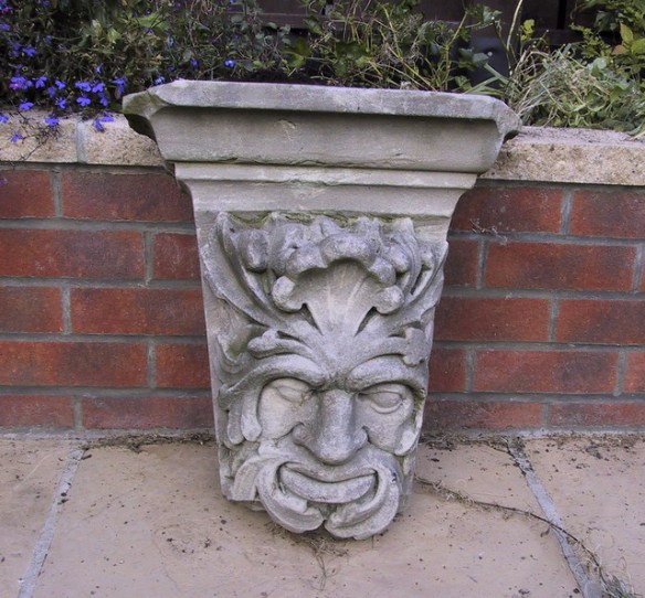
Royal Exchange Middlesbrough – Green Man

Geotag Icon Show on map

I have previously posted about another scrap of the Royal Exchange currently outside the Corus offices, so I was very happy to receive the following photograph from P Swan who previously worked for the council.

Royal Exchange Middlesbrough, Green Man
At the top of the frieze of the greek style front of the Royal Exchange was a Green Man – in the middle, a symbol for good luck. The whole facade was removed and taken to Cargo Fleet Depot. On the
demise of Cleveland County Council most of it was put in skips and cleared.

Fortunately this part survives and i’m very grateful to Mr Swan for sharing it with me.