Hawsker Cross

Geotag Icon Show on map

Hawsker Cross is thought to date from the 10th century, when a church or chapel may have stood on this site, it is missing the original cross-head.

Hawsker

My snapshot doesn’t do the carvings justice, but they have further worn since these drawing were made about a century ago.
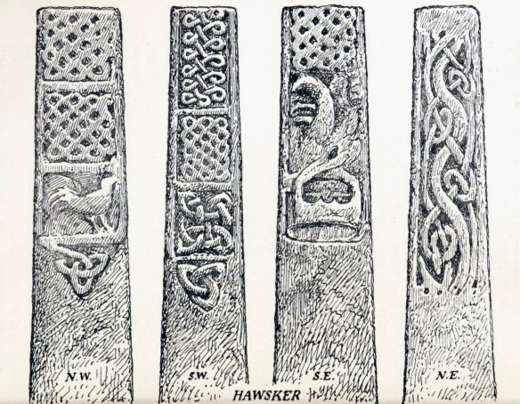
Hawsker YAJ21WG Collingwood
Anglian & Anglo-Danish Sculpture in the East Riding with addenda to the North Riding. W.G. Collingwood. Yorkshire Archaeological Journal Vol. 21 1911. Yorkshire Archaeological Society. Leeds

The patterns are said to show strong Scandinavian influences, which would have arrived with the Danes/Vikings in Whitby after 867.

First Fleet Plaque, Whitby

Geotag Icon Show on map

Two boats from Whitby the Fishburn and the Golden Grove were part of the First Fleet that set out for Botany Bay in Australia on 13th May 1787, both arriving on 20th January 1788 (less that 8 years after the discovery by Captain Cook)

First Fleet, Whitby

The fleet consisted of six convict transports carrying over 700 prisoners to the penal colony, three food and supply transports which included the Fishburn and Golden Grove, two Naval escorts the HMS Sirius and HMS Supply.

The plaque was unveiled by Sir Donald Barron on 25th June 1988 as part of the bicentenary.

Thomas Bryan Jet Merchant, Whitby

Geotag Icon Show on map

Jet workshops existed in the early 1800s, but there was a huge expansion in the 1850s after its appearence at the Great Exhibition and in the 1860s due to its strong association with Queen Victoria in mourning for Prince Albert.
Thomas Bryan Jet, Whitby
This faded sign for Thomas Bryan Jet Merchant can still be seen above modern signs at the end of Baxtergate. The 1871 Census lists Thomas Bryan living here at 76 Baxtergate where an 1890s trade directory shows him based at 4 5 and 6 Princess Place with a Mrs. Margaret Bryan at 76 Baxtergate. So perhaps between those two dates.

Black Nab Alum Quarry – Saltwick Bay

Geotag Icon Show on map

Little remains of Black Nab itself which will be completely lost to the sea at some point.
Black Nab - Saltwick Bay
The site below the cliffs is now heavily eroded and covered but its location can be seen on the first edition OS maps.

The most promenant remains are those of a harbour / breakwater below the actual quarry site, the quarry is thought to have been in use between 1649 and 1791.
Breakwater Saltwick Bay
The highlight is a 1766 datestone which has somehow survived nearly 250 years on the beach.

1766 Datestone Saltwick Bay
In the cliff at this location are the ‘Smugglers Holes’ its not really clear whether these actually relate to smuggling, the alum works or possibly jet mining (although my local expert on that tells me they are in the wrong strata)
Saltwick Bay
Saltwick Bay

Saltwick Bay Alum House

Geotag Icon Show on map

The remains of the alum house can be found at the edge of the beach and are being rapidly lost to erosion, what can be seen now is just the back wall of the structure.
Saltwick Bay Alum House
Some remains still exist under the beach itself which were excavated by the Scarborough Archaeological and Historical Society. A circular stone cistern also remains just in front of the wall but I don’t have a photo as some holiday makers were using it as a seat at the time.

Saltwick Nab – Alum Quarry

Geotag Icon Show on map

Saltwick Nab was a site of alum quarrying between 1650 and 1791, the red colouring indicates shale has been burned which is part of the alum making process.
Saltwick Nab
Saltwick Nab

An alum house existed in later years, although its though that initially the alum liquor was  taken to South Shields for processing. The remains of a stone ramp exist on the shore, which may have been used to get carts on and off the Nab.
Ramp Saltwick Bay
Ramp Saltwick Bay
Ramp Saltwick Bay

The flat area inland of the Nab has some remains of buildings and wooden pits, although the whole area has been so heavily eroded since it was worked its now difficult to interpret, it is however much more apparent on the first edition OS maps.