Cleveland Extension Mineral Railway – Paddy Waddell’s

Geotag Icon Show on map

The Cleveland Extension Mineral Railway was proposed in the 1870s to run from Kilton Thorpe to the ironworks at Glaisdale, the contractor was John Waddell.

With the collapse of mining in Eskdale the line was never completed although embankments and cuttings for the line can still be seen in several places.
Paddy Wadells

The Station Hotel was also built in anticipation at Moorsholm, but the railway never materialised.

Liverton Mines Ironstone Mine

Geotag Icon Show on map

The two capped shafts at Liverton are unusually close together.

Liverton Mines Liverton Mines

The smaller diameter upcast shaft plaque reads :-

Mine Shaft
Depth 143m
Dia 3.75m
Capped 7-4-90

Liverton Mines 

The larger downcast shaft reads

Mine Shaft
Depth 143m
Dia 4.53m
Capped 8-5-90

Liverton Mines 

The rest of the area including the shale tips has been heavily landscaped with a couple of nearby buildings being the only clue to the once industrial site.

Liverton Mines Liverton Mines

Alum House and Cementstone Kiln – Hummersea Steps

Geotag Icon Show on map

The footpath down Hummersea steps cuts right through the remains associated with the Alum House for the Loftus Alum Quarries.

Alum House, Hummersea Steps Alum House, Hummersea Steps Alum House, Hummersea Steps

The remains of the building are fast eroding out of the cliff and will likely be gone within a few years. The largest remaining stucture is thought to be a kiln for cementstone.

Alum House, Hummersea Steps Alum House, Hummersea Steps Alum House, Hummersea Steps

Nothing remains of the three story building with a large chimney which was photographed on the site around 1900, by 1910 it was a complete ruin with only a couple of small wall remnants left.

North Skelton Ironstone Mine

Geotag Icon Show on map

North Skelton mine hold a number of records. It was the last ironstone mine in Cleveland to close, having operated from the early 1870s until the 17th January 1964. It was the deepest mine in Cleveland with a 770ft shaft. It was the last in Cleveland to use a regularly use a steam winder, right up until 1951 (although Lingdale did keep one in working order as a backup until closure in 1962)
Little remains today as the site is within the current premises of Tees Components who very kindly allowed our small group to photograph the remaining buildings.

The winding house with its 1871 date stone and small door in the wall for winding ropes is the most substantial original structure.
North Skelton Ironstone Mine North Skelton Ironstone Mine

North Skelton Ironstone Mine North Skelton Ironstone Mine

Other original buildings remain, although they have been modified for other uses.
North Skelton Ironstone Mine

Outside the site is a small headframe, although the real thing was very different as can be seen against the winding house
North Skelton Ironstone Mine Monument  key29x.jpg

Loftus Alum Works

Geotag Icon Show on map

Loftus Alum works began operation in the 1650’s and ran until the 1860’s and cover roughly half a mile on a quarried shelf below the cliff. Alum is a mordant for fixing dyes to cloths.

Loftus Alum Quarry Loftus Alum Quarry

The quarrying process has left large sandstone cliffs at the back of the quarries

Loftus Alum Quarry Loftus Alum Quarry

The quarries themselves are still barren with little vegetation ever having returned to the slopes.

Loftus Alum Quarry Loftus Alum Quarry

Loftus Alum Quarry Loftus Alum Quarry

After quarrying the alum shale was burned for many months in large mounds called clamps, a process called calcining. Areas of burned red shale can be seen on the site, although its possible these are from natural fires at a later date rather than clamps.
Loftus Alum Quarry

There are the remains of several steeping pits, where the burnt alum shale would then have placed in water to dissolve the alum salts, these are rapidly nearing the cliff edge and will erode away in a few years time.
Loftus Alum Quarry Loftus Alum Quarry

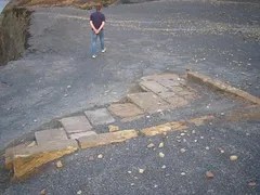
Carved stone troughs can also be found which would have transported liquids around the site.

Loftus Alum Quarry

The alum liquor would have been transferred into a tank or cistern to allow any particles to settle out, a double walled circular cistern can be still be seen protruding from the edge of the cliff.

Loftus Alum Quarry

The settled liquor would then have been transferred to the Alum House where it was concentrated by evaporation until a specific concentration was reached, said to be the point where an egg would float in it. Akali (usually kelp or urine) was then added and the alum crystals formed as the liquid cooled.

INDUSTRIAL HERITAGE WALK – Grosmont and Esk Valley – 13:00 – 13/09/09

Geotag Icon Show on map

INDUSTRIAL HERITAGE WALK
Sunday 13th September

Around Grosmont and Esk Valley

Meet outside St. Matthew’s Parish Church
At 1pm for a short walk
Over Lease Rigg
Return approx. 5pm

Details will include Hagg’s mine and Esk Valley mine, description of mining methods and tour of loco sheds.
Exhibition inside the Church.

Walk led by Simon Chapman
Author of Grosmont and it’s mines.
Refreshments included